Community Gems: The Table Rocks
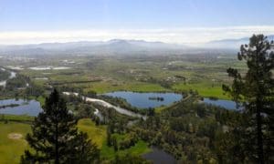
Home to nearly 218,000 residents, Jackson County is constantly growing as more and more people realize the beauty and business opportunities Southern Oregon has to offer. For most of these residents, two cliff-edged mesas mark the Southern Oregon skyline. Both the Upper and Lower Table Rocks, labeled a “haven for hikers and endangered wildflowers,” are definite jewels among Southern Oregon, attracting over 45,000 visitors each year. With a plethora of rare bird and plant species, as well as gorgeous views sweeping all the way to the Crater Lake Rim and Mt. Mcloughlin, it’s no wonder the Table Rocks make the list of Southern Oregon highlights.
Contrary to common assumption, the Lower Table Rock is not actually the shorter one. They are both named according to their positions along the Rogue River, (not just for the purpose of baffling hikers). The horseshoe shaped mesas were created by lava flows, which explain the unique jagged cliff-sides and the volcanic rock on the plateaus. Hiking the Upper Table Rock is generally easy, with a 2.8 mile trail which gains 720 feet. The Lower Table Rock is around half a mile longer, with a 780 foot increase in height. If you’re planning a first-time hiking trip, locals will recommend giving yourself at least three hours, allowing for ample exploring time once you reach the top.
Fun facts about the Table Rocks usually include mention of the airstrip on top of the Lower Table Rock. Did you know you can walk all the way across it for one of the best view points on the mountain? Wooly dwarf meadowfoam, a rare species of plant, only makes its home one place in the whole world…you guessed it—the Table Rocks in Southern Oregon! The vernal pools on top of the Lower Table Rock provide ripe conditions for other threatened wildlife, making a hike on Table Rock any nature-lover’s dream. The Lower Table Rock was also declared a nature preserve by the non-profit Nature Conservancy in 1979.
Even farther back, the Upper Table Rock was a refuge point for the Takelma Indian Tribe, who was countered by the U.S. Army after launching an attack against the influx of miners and settlers arriving in search of gold. Because of the Upper Table Rock’s shape, it proved to be a natural fortress against the military, which eventually sent in Joe Lane and Joel Palmer as peace negotiators. They allowed the Takelmas to keep the Table Rocks as part of the Table Rock Treaty in September of 1853, and in addition to this short-lived reservation, the army built nearby Fort Lane to help protect the Tribe from rogue settlers. By the end of 1855 however, the settlers had taken to killing the native peoples for sport, and the Rogue River Wars (between the Indian Tribes and the settlers), resulted in the removal of the Takelma people from the Table Rock Reservation. In the late fall of 1856, Fort Lane was decommissioned and all but destroyed, though now the bare remains of the site (found off Gold Ray Rd, Central Point), belong to the National Register of Historic Places.
All this said, next time you’re in the mood for a hike, check out one of the Table Rocks. With their intense history, rich wildlife, and scenic vistas, the twin mesas provide free adventure—and good exercise—for the young and old alike.
Additional Sources:
Sullivan, William (2019). Hike Table Rocks. Oregon.com. Website: http://www.oregon.com/recreation/hike-table-rocks
Tveskov, Mark (2019). Fort Lane. The Oregon Encyclopedia. Website: https://oregonencyclopedia.org/articles/fort_lane/#.XMt4mOVKiUl
Travel Medford (2022). Visit Table Rocks Near Medford, Oregon. Website: https://www.travelmedford.org/table-rocks
© 1987-2026 SOREDI 100 E Main Street, Suite A • PO Box 4672 • Medford, OR 97501 • Phone: (541) 773-8946