Great Spaces: Illinois Valley Adventures
Also referred to as the Gateway to the Redwoods (and the Gateway to the Southern Oregon Coast), the Illinois Valley is home to several thousand residents—and adventure itself. Recently, the Illinois Valley partnered with Travel Southern Oregon to create an ‘Adventure Map,’ which highlights the variety of activities one can find in this lesser-known corner of Southern Oregon. “You might pass right through the area—unless you know better,” says Lindsey Jones, who works for IVCanDO (the Illinois Valley Community Development Organization). “You can easily spend a whole day here—or a whole vacation.”
The purpose of the adventure map is to remind Southern Oregon—and beyond—that there are activities in the region for everyone. From family-friendly museums, and wheelchair accessible nature walks, to extreme hiking and rafting opportunities, the Illinois Valley is host to a variety of pastimes.
“We had great collaboration on the Adventure Map,” says Jones, praising the numerous partnerships that brought expertise to the project. From the US Forest Service to park volunteers, the group designing the map was able to select the best trailheads, scenic byways, and even provide updated information about museums and the Slater Fire burn zones. “We have so much to see and do—it’s worth spending time here,” Jones concludes.
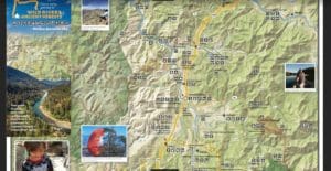
Some spots on the adventure map might already be familiar. For instance, you may have visited the Oregon Caves, one of Oregon’s four National Monuments—and have the tee-shirt to prove it. Yet on the other hand, the hidden swimming holes tucked along miles of hiking trails at Eight Dollar Mountain may be a surprise. If you haven’t been out to the Illinois Valley in a while, you may want to take a peek at the Adventure Map (found here on the Illinois Valley website), or keep reading this article for a few (of the many) new daytrip ideas.
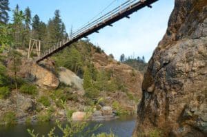
The Illinois River Swinging Bridge can be a challenge to get to on hot summer days—simply because it’s such a popular spot for river recreation. Sixty-feet above the water, the 1963 hanging bridge is fun for those who don’t mind heights, or for those hoping to get an aerial view of the clear water below. However, if high bridges are not one’s forte, there are plenty of spots for swimming, diving, and easy paddleboard access along the riverbanks.
Illinois River Forks State Park is not only ADA accessible but also a great spot for extensive nature viewing, disc golf, equestrian trails, hiking, running, and swimming. Its location near Cave Junction makes the park convenient for a day of free activities—and then a trip into town for a hot meal or ice cream.
The Red Buttes Wilderness has almost four-thousand acres in Josephine County and includes recreation areas such as Bolan and Tanner Lakes. In addition to an assortment of hikes and beautiful mountain scenery, the wilderness is home to animals such as the ring-tailed cat and the peregrine falcon.

Lake Selmac, one of Josephine County’s southernmost parks, is another great spot for camping and fishing. Often during the summer, Lake Selmac features an assortment of community activities for Cave Junction, Kerby, Selma, and the other outlying towns.
Bigelow Lakes sit side-by-side on the land belonging to the Oregon Caves National Monument and Preserve. A trailhead marks a simple one-mile loop trail. While the lakes themselves may be scenic picnic spots, Grayback Mountain* is also nearby, providing more opportunities for biking, hiking, and horseback riding.
For Winter activities, don’t forget Page Mountain Sno-Park..* Most years, the mountain sees several feet of snow and hundreds of enthusiastic visitors. Day passes (one-time only), cost $4.00—which is a low price for a full day of skiing, snowboarding, snowshoeing, and tubing.
No matter where you decide to explore in the Illinois Valley, stay safe, have fun, and thank the locals—for sharing the natural beauty of their area with anyone who stops by a tourist information center and picks up an Adventure Map.
*Always check for road closures and clean-up boundaries, especially in areas that have seen recent wildfires. This information can be found on forest service websites here.
* Swinging Bridge Photo taken from Oregonlive.com
(One Rogue Valley Strategy 4.4.2.– Diversify Outdoor Recreation Offerings to Include Shoulder, Low-Season, and Off-Season Opportunities and Promote Tourism at Lesser-Known Destinations)
© 1987-2026 SOREDI 100 E Main Street, Suite A • PO Box 4672 • Medford, OR 97501 • Phone: (541) 773-8946